CBSE Class 6 Social Science Chapter 1 – Locating Places on the Earth covers the importance of studying society, geography, and history together.
These NCERT-based Q&A are simplified for young learners, aligned with the 2025 updated syllabus. The answers are written in simple English for Class 6 students and help build strong concepts for map reading, time zones, directions, and more.
🌍 Welcome to Social Science! 📚
“How can we solve humanity’s problems? How can we live in peace and protect our beautiful Earth?”
These big questions are what Social Science helps us explore!
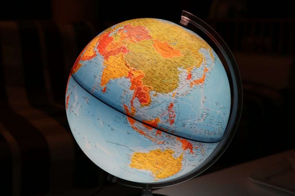
“The globe stands in space, made of water, earth, fire and air – spherical and surrounded by all creatures.”– Āryabhaṭa (500 CE)
❓ The Big Questions:
- 🗺️ What are maps and how do we use them?
- 📍 How do latitude/longitude help locate any place?
- ⏰ Why does time change across longitudes?
🗺️ Map Reading 101
🧭 Cardinal Directions
North, South, East, West + NE, NW, SE, SW
📏 Scale
1 cm = 500 km (example)
Helps fit big areas on small paper!
🖍️ Symbols
Universal signs for roads, rivers, buildings
📍 Earth’s GPS: Latitude & Longitude
🌐 Latitude
- Parallel circles from Equator (0°) to Poles (90°)
- Affects climate: Hot at Equator ❄️ Cold at Poles
🌐 Longitude
- Half-circles from Pole to Pole
- Prime Meridian at Greenwich (0°)
- Determines time zones ⏰
Latitude (horizontal) + Longitude (vertical) = Earth’s address system!
⏰ Why Time Changes Across Earth
🌞 Earth’s Rotation
15° longitude = 1 hour time difference
360° ÷ 24 hours = 15°/hour
🇮🇳 Indian Standard Time (IST)
Based on 82.5°E longitude (Mirzapur, UP)
5.5 hours ahead of Greenwich (GMT)
🌟 Did You Know? Russia has 11 time zones! 🕚
🔍 Let’s Explore!
1. Map Your Classroom 🏫
Draw a map showing:
- Teacher’s desk 🪑
- Blackboard 🖍️
- Windows & doors 🚪
- Add a compass! 🧭
2. Time Zone Math 🧮
If it’s 12pm in London:
- What time is it in Delhi (GMT+5.5)?
- What time in New York (GMT-5)?
1. Returning to page 10 and to Fig. 5.2 in Chapter 5 of this textbook, taking the scale to be 2.5 cm = 500 km, calculate the real distance from the estuary of the Narmada River to the estuary of the Ganga river.
Answer:
Let’s say the map distance is 6 cm (rounded).
Using the scale:
➡️ 1 cm = 200 km
➡️ So, 6 cm = 6 × 200 = 1200 km
👉 The real distance is approximately 1200 km.
2. Why is it 5:30 pm in India when it is 12 pm or noon in London?
Answer:
India is 5 hours and 30 minutes ahead of London because of different time zones. As the Earth rotates, the Sun appears in different places at different times. 👉 So when it is 12 noon in London, it is 5:30 pm in India.
3. Why do we need symbols and colours in the map?
Answer:
Maps are small and can’t show everything clearly. ✅ Symbols show places like schools, rivers, roads. ✅ Colours show features like water (blue), forests (green), deserts (yellow). 👉 They help us read maps easily.
4. Find out what you have in the eight directions from your home or school.
Answer:
Example (can be customized by students):
– North: Main Road
– South: Playground
– East: Temple
– West: Market
– NE: Friend’s House
– NW: Park
– SE: School Gate
– SW: Big Tree
5. What is the difference between local time and standard time?
Answer (100–150 words):
Local time is the time at a place based on the Sun. When the Sun is overhead, it is 12 noon at that place. Every place has a different local time. But if everyone follows different clocks, it becomes confusing. So, countries follow a Standard Time. In India, we use the time at 82.5° E longitude as our Standard Time. This is called Indian Standard Time (IST). 👉 Even though Assam sees sunrise earlier and Gujarat sees it later, both use IST. This makes communication and planning easier across the country.
6. Delhi’s and Bengaluru’s latitudes are 29°N and 13°N; their longitudes are almost the same, 77°E. How much will be the difference in local time between the two cities?
Answer:
Delhi and Bengaluru have the same longitude (77°E). 👉 Local time depends on longitude, not latitude. So, there is no time difference between the two cities.
7. Mark the following statements as true or false; explain your answers with a sentence or two.
| Statement | True/False | Explanation |
|---|---|---|
| All parallels of latitude have the same length. | ❌ False | Only the Equator is the longest; others are shorter near the poles. |
| The length of a meridian of longitude is half of that of the Equator. | ✅ True | Meridians go from pole to pole; the Equator is a full circle. |
| The South Pole has a latitude of 90°S. | ✅ True | It is at the southernmost point of the Earth. |
| In Assam, the local time and the IST are identical. | ❌ False | Assam is in the east, so sunrise is earlier than IST. |
| Lines separating the time zones are identical with meridians of longitude. | ✅ True | Time zones are based on longitudes (15° apart). |
| The Equator is also a parallel of latitude. | ✅ True | The Equator is the main 0° parallel of latitude. |
📘 Tip: These questions are part of the updated CBSE Class 6 Social Science 2025 syllabus based on NCERT’s new book. Understanding maps, directions, time, and symbols is the foundation of geography and social studies.
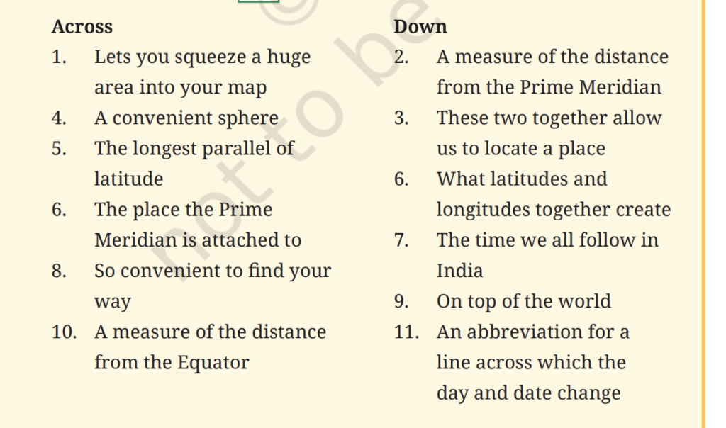
✅ Crossword Answers:
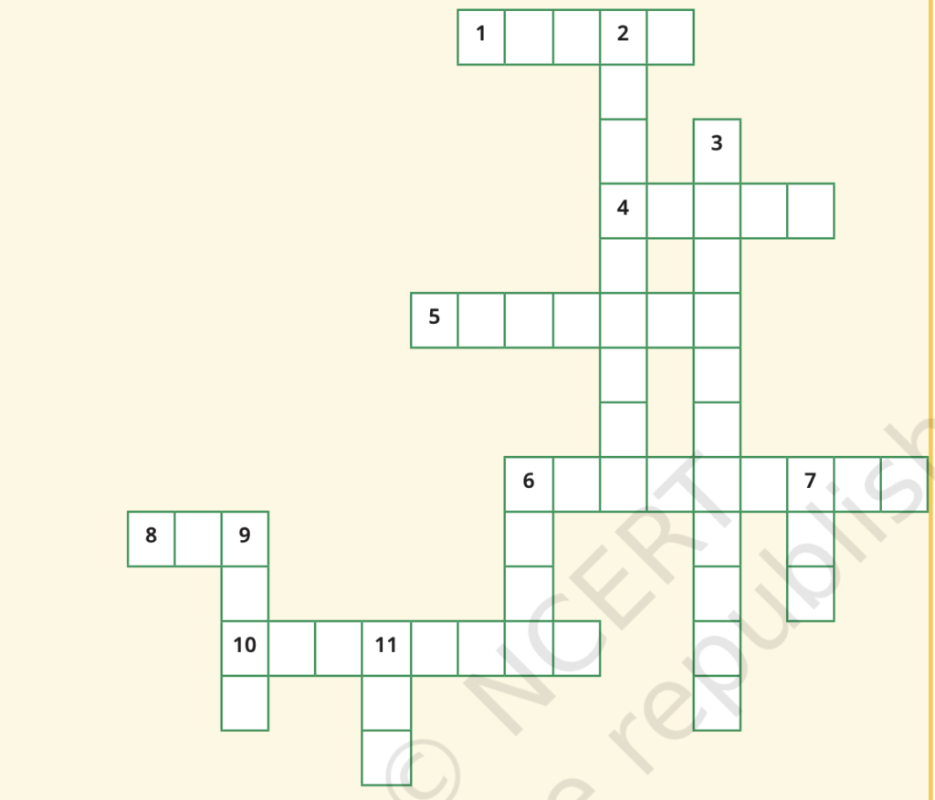
Across:
- Scale – Lets you squeeze a huge area into your map
- Globe – A convenient sphere
- Equator – The longest parallel of latitude
- Greenwich – The place the Prime Meridian is attached to
- Compass – So convenient to find your way
- Latitude – A measure of the distance from the Equator
Down:
- Longitude – A measure of the distance from the Prime Meridian
- Grid – These two together allow us to locate a place
- Grid – What latitudes and longitudes together create (shared answer with 3 Down)
- IST – The time we all follow in India
- Pole – On top of the world
- IDL – An abbreviation for a line across which the day and date change (International Date Line)